The ingredients are coming together for a rare fall-season outbreak of severe weather weather in the Plains on Monday. The primary driver for this threat is a powerful upper-level trough entering the Plains from the western U.S. The flow at 500 mb will range from 40 kts, to a blistering 90 kts at the center of the jet streak.

NAM
500 mb
6 pm, November 16th
pivotalweather.com
Air will move down the Rocky Mountains, creating relatively low pressure east of the mountains. As a result, a very strong pressure gradient will develop. This will lead to the development of a powerful low-level jet, as can be seen in the NAM 850 mb forecast.

NAM
850 mb
6 pm, November 16th
pivotalweather.com
The resulting strong southerly low-level winds will transport unseasonably high moisture northward toward the Plains. Dewpoints will be rather high for November, with the 60 F dewpoint line far into the Texas Panhandle.

NAM
Surface
6 pm, November 16th
pivotalweather.com
The colder temperatures high in the atmosphere and moist air at the surface will combine to produce substantial instability over the Southern Plains.

NAM
Surface Based CAPE
6 pm, November 16th
pivotalweather.com
Though surface-based convective available potential energy (SBCAPE) values will be somewhat low, large values of shear should compensate. Deep-layer shear (0-6 km) should be more-than-sufficient for the development of strong supercells. And the all-important low-level shear values should be nothing short of incredible. According to the 4 km NAM, values will exceed 200 m2/s2 in most places.

NAM 4 km
0-1km Storm Relative Helicity
6 pm, November 16th
pivotal weather.com
Generally speaking, tornadoes are possible when values exceed a 100 m2/s2. So, with values well over 200 – and in some cases, over 400 – you get the idea that we could be in for a rather bumpy Monday evening.
The full effect can be quantified by the significant tornado parameter. Values greater than 1 indicate the potential for tornadoes. In this 4 km NAM forecast, local modifications of the storm environment result in values over 5!
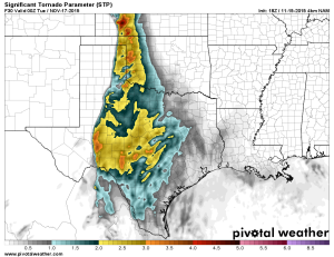
NAM 4 km
Significant Tornado Parameter
6 pm, November 16th
pivotalweather.com
Based on the aforementioned ingredients, the Storm Prediction Center has issued an enhanced risk for severe weather for most of the Southern Plains.

Day 2 Outlook
Storm Prediction Center
November 16th
As far as timing is concerned, most higher resolution models are calling for isolated development to begin between 3 and 6 pm. The NAM 4 km (featured here) is producing a couple of robust-looking supercells over west Texas into western Oklahoma by 6 pm.

NAM 4 km
Simulated Reflectivity
6 pm, November 16th
pivotalweather.com
These storms are forecast to move into western Oklahoma and western north Texas after dark. This forecast sounding in southwestern Oklahoma shows a deep moisture layer, significant CAPE, and extremely strong low-level shear.

NAM 4 km
Forecast Sounding
Near Gotebo, OK
pivotalweather.com
Given the relatively cool surface temperatures and moist air, the cloud bases forecast to be a low 500 m. So, no surprise: the forecast analogs favor tornadoes.
More importantly, the capping inversion will remain relatively weak throughout the evening. So it is quite possible that storms will produce tornadoes after dark. This reflectivity forecast gives the idea that small line segments may form, but semi-discrete storms could persist toward 9 pm.

NAM 4 km
Simulated Reflectivity
6 pm, November 16th
pivotalweather.com
In summary, there is a good chance of significant severe weather across west Texas into western Oklahoma, with the threat of large hail, damaging hail, and tornadoes. There is definitely no guarantee of an outbreak of tornadoes, but it would be good to start reviewing your tornado safety plan – especially if you live in western Oklahoma or west Texas.


NOW YORK CITY
CHANA CITY